
Top AI Repos — open-source AI, indexed and scored
Top AI Repos tracks AI repositories on GitHub and answers two different questions about each one: is it moving right now, and would you bet a product on it.
Top AI Repos tracks AI repositories on GitHub and answers two different questions about each one: is it moving right now, and would you bet a product on it.

Shenzhen MSU-BIT University PolarBear Team's Sentry Navigation Sim2Real Package for RoboMaster2025. QQ group: 932119307
| Date | Stars |
|---|---|
| 2026-07-24 | 394 |
| 2026-07-25 | 394 |
| 2026-07-28 | 395 |
| 2026-07-30 | 395 |
| 2026-08-10 | 402 |
| 2026-08-18 | 411 |
| 2026-08-19 | 412 |
| 2026-08-20 | 412 |
| 2026-08-23 | 413 |
| 2026-08-24 | 416 |
| 2026-08-26 | 417 |
| 2026-08-28 | 417 |
| 2026-08-29 | 418 |
| 2026-08-30 | 420 |
| 2026-09-01 | 423 |
| 2026-09-03 | 426 |
| 2026-09-04 | 427 |
| 2026-09-05 | 427 |
| 2026-09-07 | 427 |
| 2026-09-09 | 429 |
| 2026-09-10 | 429 |
| 2026-09-11 | 430 |
| 2026-09-13 | 429 |
| 2026-09-14 | 429 |
| 2026-09-20 | 429 |
Today
— stars today
This week
— stars this week
This month
+17 stars this month
Momentum
0.0
growth rate 0.00%/day
# pb2025_sentry_nav
[](https://opensource.org/licenses/Apache-2.0)
[](https://github.com/SMBU-PolarBear-Robotics-Team/pb2025_sentry_nav/actions/workflows/build_and_test.yml)
[](https://github.com/pre-commit/pre-commit)
深圳北理莫斯科大学 北极熊战队 2025 赛季哨兵导航仿真/实车包

[BiliBili: 谁说在家不能调车!?更适合新手宝宝的 RM 导航仿真](https://www.bilibili.com/video/BV12qcXeHETR)
https://github.com/user-attachments/assets/d9e778e0-fa43-40c2-96c2-e71eaf7737d4
https://github.com/user-attachments/assets/ae4c19a0-4c73-46a0-95bd-909734da2a42
## 1. Overview
本项目基于 [NAV2 导航框架](https://github.com/ros-navigation/navigation2) 并参考学习了 [autonomous_exploration_development_environment](https://github.com/HongbiaoZ/autonomous_exploration_development_environment/tree/humble) 的设计。
- 关于坐标变换:
本项目大幅优化了坐标变换逻辑,考虑雷达原点 `lidar_odom` 与 底盘原点 `odom` 之间的隐式变换。
mid360 倾斜侧放在底盘上,使用 [point_lio](https://github.com/SMBU-PolarBear-Robotics-Team/point_lio/tree/RM2025_SMBU_auto_sentry) 里程计,[small_gicp](https://github.com/SMBU-PolarBear-Robotics-Team/small_gicp_relocalization) 重定位,[loam_interface](./loam_interface/) 会将 point_lio 输出的 `/cloud_registered` 从 `lidar_odom` 系转换到 `odom` 系,[sensor_scan_generation](./sensor_scan_generation/) 将 `odom` 系的点云转换到 `front_mid360` 系,并发布变换 `odom -> chassis`。
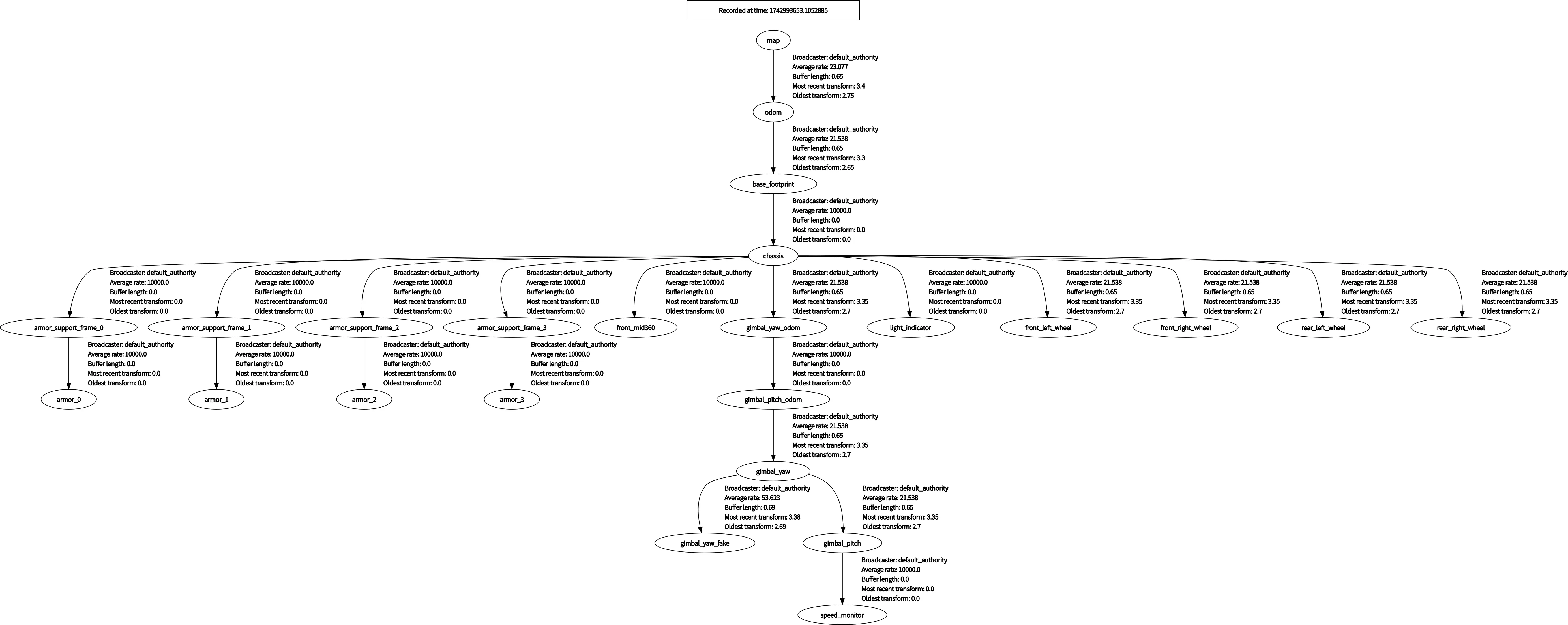
- 关于路径规划:
使用 NAV2 默认的 Global Planner 作为全局路径规划器,pb_omni_pid_pursuit_controller 作为路径跟踪器。
- namespace:
为了后续拓展多机器人,本项目引入 namespace 的设计,与 ROS 相关的 node, topic, action 等都加入了 namespace 前缀。如需查看 tf tree,请使用命令 `ros2 run rqt_tf_tree rqt_tf_tree --ros-args -r /tf:=tf -r /tf_static:=tf_static -r __ns:=/red_standard_robot1`
- LiDAR:
Livox mid360 倾斜侧放在底盘上。
注:仿真环境中,实际上 point pattern 为 velodyne 样式的机械式扫描。此外,由于仿真器中输出的 PointCloud 缺少部分 field,导致 point_lio 无法正常估计状态,故仿真器输出的点云经过 [ign_sim_pointcloud_tool](./ign_sim_pointcloud_tool/) 处理添加 `time` field。
- 文件结构
```plaintext
.
├── fake_vel_transform # 虚拟速度参考坐标系,以应对云台扫描模式自旋,详见子仓库 README
├── ign_sim_pointcloud_tool # 仿真器点云处理工具
├── livox_ros_driver2 # Livox 驱动
├── loam_interface # point_lio 等里程计算法接口
├── pb_teleop_twist_joy # 手柄控制
├── pb2025_nav_bringup # 启动文件
├── pb2025_sentry_nav # 本仓库功能包描述文件
├── pb_omni_pid_pursuit_controller # 路径跟踪控制器
├── point_lio # 里程计
├── pointcloud_to_laserscan # 将 terrain_map 转换为 laserScan 类型以表示障碍物(仅 SLAM 模式启动)
├── sensor_scan_generation # 点云相关坐标变换
├── small_gicp_relocalization # 重定位
├── terrain_analysis # 距车体 4m 范围内地形分析,将障碍物离地高度写入 PointCloud intensity
└── terrain_analysis_ext # 车体 4m 范围外地形分析,将障碍物离地高度写入 PointCloud intensity
```
## 2. Quick Start
### 2.1 Option 1: Docker
#### 2.1.1 Setup Environment
- [Docker](https://docs.docker.com/engine/install/)
- 允许 Docker Container 访问宿主机 X11 显示
```bash
xhost +local:docker
```
#### 2.1.2 Create Container
```bash
docker run -it --rm --name pb2025_sentry_nav \
--network host \
-e "DISPLAY=$DISPLAY" \
-v /tmp/.X11-unix:/tmp/.X11-unix \
-v /dev:/dev \
ghcr.io/smbu-polarbear-robotics-team/pb2025_sentry_nav:1.3.2
```
### 2.2 Option 2: Build From Source
#### 2.2.1 Setup Environment
- Ubuntu 22.04
- ROS: [Humble](https://docs.ros.org/en/humble/Installation/Ubuntu-Install-Debs.html)
- 配套仿真包(Option):[rmu_gazebo_simulator](https://github.com/SMBU-PolarBExcerpt of 8,861 characters
Read on GitHubWould you bet a product on this? Bounded 0–100 and slow moving.
matched fp:9b5076dd93c9c304, topic:robotics, topic:ros2, readme:robotics